CINCINNATI — Severe thunderstorms carved a path of damage across the Tri-State Monday afternoon and evening. Straight line damaging winds were the main reason why so many trees came down and so many lost power. 60-70 mph winds were picked up across many of our Ohio counties.
But why did this happen and does this qualify as a derecho?
First let's talk about if this was a derecho. A bigger, long-lasting line of storms from Chicago through central Ohio did qualify as a derecho, but that missed our area. I spoke with our National Weather Service Office in Wilmington Tuesday morning about the cluster of storms that started east of Indianapolis, went through Cincinnati and continued to Charleston, WV to see if that cluster of storms and damage qualified. An answer cannot be given as a 10 a.m. Tuesday but it is being evaluated. They are calling neighboring offices to come to an agreement.
What is a derecho? We experienced a big event like this back in 2012. Here's the official definition from the NWS:
- A derecho (pronounced "deh-REY-cho") is a widespread, long-lived wind storm that is associated with a band of rapidly moving showers or thunderstorms. Although a derecho can produce destruction similar to the strength of tornadoes, the damage typically is in one direction along a relatively straight swath. As a result, the term "straight-line wind damage" sometimes is used to describe derecho damage. By definition, if the wind damage swath extends more than 240 miles (about 400 kilometers) and includes wind gusts of at least 58 mph (93 km/h) or greater along most of its length, then the event may be classified as a derecho.
- MORE: Derecho Information
If you look at the damage reports from our event yesterday, it stretches for more than 240 miles but what we are waiting to get clarification on is if it's consistent damage to meet the qualification of derecho.
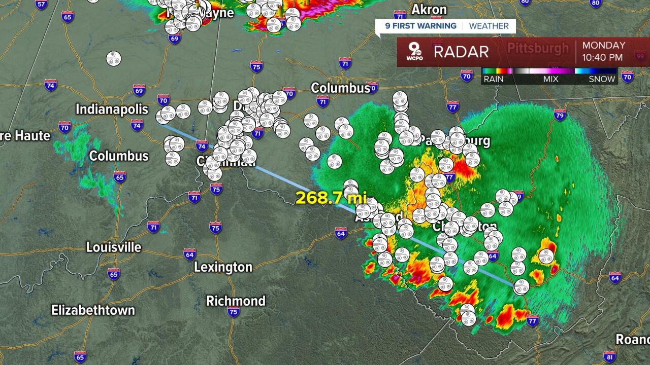
Either way, it was a BIG day for the Tri-State and we are still reeling from the damaging wind gusts. And the situation escalated quickly from 4-7 p.m.
By 5 p.m., it had become evident on radar that a large cluster of storms had stopped moving northeast and winds were accelerating behind the leading edge of intense rain. At this point, large-spanning severe thunderstorm warnings were put out ahead of the storm because it was obvious the storm was about to devolve into a damaging wind event and spread quickly east and southeast.

At 6 p.m. that bowing line of storms had moved into the Cincinnati metro area but was ripping across Butler County, too. This is when so many trees came down in that county, taking out power left and right. This push of storms led to 20% of that county without power. Estimated wind gusts were at 70-75 mph at times, especially to the north.

At 7 p.m., the bowing structure of storms was still evident on radar as it moved into Highland, Adams and Clinton County, continuing to produce damage.

So why did this happen? We had an incredible amount of energy available in the atmosphere Monday afternoon and sweltering humidity. All that was needed was a lifting mechanism to start the event and as a warm front did some subtle lifting, the energy and humidity did the rest of the work. There was one point on Monday afternoon that we had over 6,000 joules of CAPE. That exceeds the energy needed to produce a severe storm by nearly 3-fold!
If this doesn't get called a derecho, it was indeed an impressive bowing segment of storms. It was textbook in appearance. Your photos proved that on Monday evening.
Check out this shelf cloud photo taken by Mike DeMarsh from northern Kentucky:

We even had impressive photos of scud clouds. As you can see below from this picture from Brian C., it almost looks like a tornado at first glance. But the jagged appearance of the cloud shows there's no rotation. You are looking at the storms updraft and the cloud condensing right before your eyes.