GOSHEN, Ohio — The National Weather Service (NWS) confirmed Thursday that an EF2 tornado touched down in Goshen Wednesday.
The NWS defines an EF2 as a "strong" tornado with wind speeds between 111 mph to 135 mph. In a report issued Thursday afternoon, it estimated the tornado started in Newtonsville and traveled to Pleasant Plain between 3:08 p.m. and 3:12 p.m. Wednesday afternoon.
The tornado reached maximum wind speeds of 130 mph, traveled 2.5 miles and cut a swath 750 yards wide, NWS said.
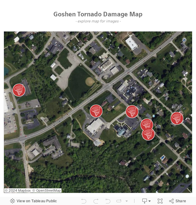
"Initial damage consisting of dozens of snapped and uprooted trees was noted just southeast of the Huntley Road/Goshen Road intersection," reads the NWS report.
The tornado strengthened as it reached Goshen before crossing Main Street, causing significant damage to businesses, the NWS said.
"The large and strong tornado then crossed Highway 28, significantly damaging a fire station and causing complete roof loss to a brick business next door," the report says. "This was the strongest point in the tornado life cycle, with winds estimated around 130 mph."
From there, the tornado moved southeast along Goshen Road, snapping hundreds of trees and damaging homes. The tornado hit both the middle and high schools, causing roof and siding damage.
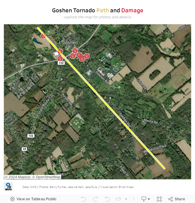
Because of road closures, the NWS said the survey team wasn't able to examine damage past the intersection of Woodville Pike and Goshen Road, but the team was able to see tree damage visible to the southeast of Woodville Pike. The NWS has declared that to be the end of the tornado's path, but said because they couldn't access the area further, the path could have extended further southeast; NWS will re-assess when the roads have been cleared, according to their report.
The NWS said it sent a survey team from Wilmington in coordination with Clermont County Emergency Managment to survey the damage.
Goshen Township declared a state of emergency after multiple buildings were severely damaged by the tornado. Duke Energy said power will likely be out in the region for days.
Here's breakdown of the storm's development:
This radar scan shows the storm as it moved through Clermont County. The notch wrapping into the line of storms shows an evident rotation even on basic radar analysis.
Check out the next three tweets for a review of the radar from Clermont County on Wednesday. First, here's the radar loop, showing the purple polygon tornado warning, it confirms we indeed had a tornado based on radar analysis. @wcpo #cincywx pic.twitter.com/ANPrbBUdbD
— Jennifer Ketchmark (@KetchmarkWCPO) July 7, 2022
This radar loop is the storm's relative velocity. This is a tool scientists use to see where there is rotation in a thunderstorm. The data shows the rotation started just west of Goshen and became much more defined as it came into town and continued to the east.
Up next, the storm relative velocity from Wednesday afternoon as the storm moved through Goshen. You are looking for the red and green to come close together... I've circled the area of concern. @wcpo #cincywx pic.twitter.com/bey5Fdsmxp
— Jennifer Ketchmark (@KetchmarkWCPO) July 7, 2022
This radar loop shows where there is debris in the atmosphere. This is one of those radar products that makes it abundantly clear when there is or isn't a tornado. The bright blue "pop" on the radar scan as it passes downtown Goshen is literally trees, pieces of homes, basically anything in the path of the tornado that was thrown up into the atmosphere.
And this final loop shows the debris signature being picked up on radar near Goshen. When the blue colors pop. that's stuff from homes, trees, etc. being picked up and seen on radar. This is the definitive element that says "YES!" we have a tornado. @wcpo #cincywx pic.twitter.com/N6Ik3wrIZ6
— Jennifer Ketchmark (@KetchmarkWCPO) July 7, 2022
The NWS said a separate survey team will be investigating damage this afternoon in far northern Brown County near Lake Lorelei in regards to the storms that occurred yesterday.
The NWS said that if time allows, it may also travel to Villa Hills, KY for another possible tornado analysis.
READ MORE
Latest on power outages; at one point more than 100,000 were without power
'We weren't sure we were going to make it out' | Tornado touches down in Goshen, destroying buildings