


CINCINNATI — Ohio's primary Tuesday marked the first election under a new congressional map.
Passed by the state redistricting commission in late 2025, the new map made extensive changes to the borders of Ohio's District 1, which includes Cincinnati. Several other areas, like District 9 in Northwest Ohio, saw changes, too.
"For the average Ohioan, it's not very drastic," David Niven, professor of political science at the University of Cincinnati, said. "This is more of an attack at the margins."
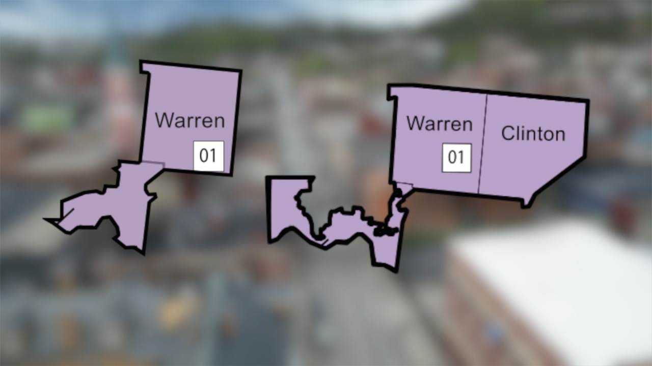
Under the previous map, Ohio’s District 1 was split between Democratic-leaning Hamilton County and Republican stronghold Warren County. The new map keeps Warren County but adds pieces of deep-red Clinton County and more conservative parts of western Hamilton County.
“It does shift the balance to light pink,” Shauna Reilly, political science professor at Northern Kentucky University, said. "Depending on a few factors, maybe a little deeper than light pink."
Previously at 10-to-5 in favor of Republicans, the redistricting changes give Ohio's GOP a theoretical 12-to-3 advantage in congressional races. But Niven said in action, that may not be the case.
"Certainly, though, District 1 was drawn to be more favorable to Republicans than it already was," Niven said. "It's an interesting example where the (Republican) party went to a great deal of trouble to draw itself a favorable map, and then didn't go to the trouble of recruiting a candidate with high name recognition or campaign experience that might help them actually win the seat."
WATCH: How might the new congressional map impact Ohio District 1?
Niven said compared to other states engaged in mid-decade redistricting, the changes to Ohio's map are no where near as drastic.
"With the recent Supreme Court ruling, states like Tennessee are jumping in, literally to eliminate the one Democratic seat that exists in the state of Tennessee," he said.
In a statement, Tenessee Gov. Bill Lee said the review follows “renewed nationwide action around congressional representation.”
Niven said that, while only marginal changes have been made to the map, it will have an outsized impact on communities now belonging to a new district.
“They’re different. Economically, they’re different, culturally. It’s a difficult task,” he said of Cincinnati, Warren County and Clinton County residents. “It would be impossible for any representative to speak the language, the economic language, to represent the concerns of all three.”
Four Republicans are running in the 2026 primary to challenge the winner of Democratic incumbent Greg Landsman's primary race. None of the GOP candidates currently hold elected office.
Niven said that in a strong Republican midterm year, the map might have flipped the district. But given current political conditions, including higher-than-expected Democratic turnout in recent off-year elections, he said Landsman is “in good shape” for re-election.
"(Landsman) doesn't have in November the kind of candidate who might try to capture the middle of the district," Niven said. "Whoever his Republican opponent is going to be, they're going to be a very, very conservative and Trump-supporting candidate."
Historically, the president’s party loses seats in midterm elections, especially if the economy sours or presidential approval dips. Reilly said predicting the outcome is premature.
“I wish I had a crystal ball, I could tell you, but I don’t think that answer is available just yet,” she said.
Ohio’s new map will be used in the 2026, 2028 and 2030 elections.
This story was reported on-air by a journalist and has been converted to this platform with the assistance of AI. Our editorial team verifies all reporting on all platforms for fairness and accuracy.
