


SATURDAY AND SUNDAY ARE 9 FIRST WARNING WEATHER ALERT DAYS
OVERNIGHT: The forecast remains quiet but incredibly cold. Our low of 4 degrees will feel like -12 in the morning. A COLD WEATHER ADVISORY is out through noon Saturday. You should try to limit your time outside.

SATURDAY MORNING: The day starts dry, cold and cloudy. A WINTER STORM WARNING is out from the National Weather Service starting Saturday at 10 a.m. and continuing through noon Monday.
Snow will begin to fall in our southern locations between 10 a.m. and noon. This will be very light to start and will fall around the Greater Cincinnati area between 12 pm and 2 pm.

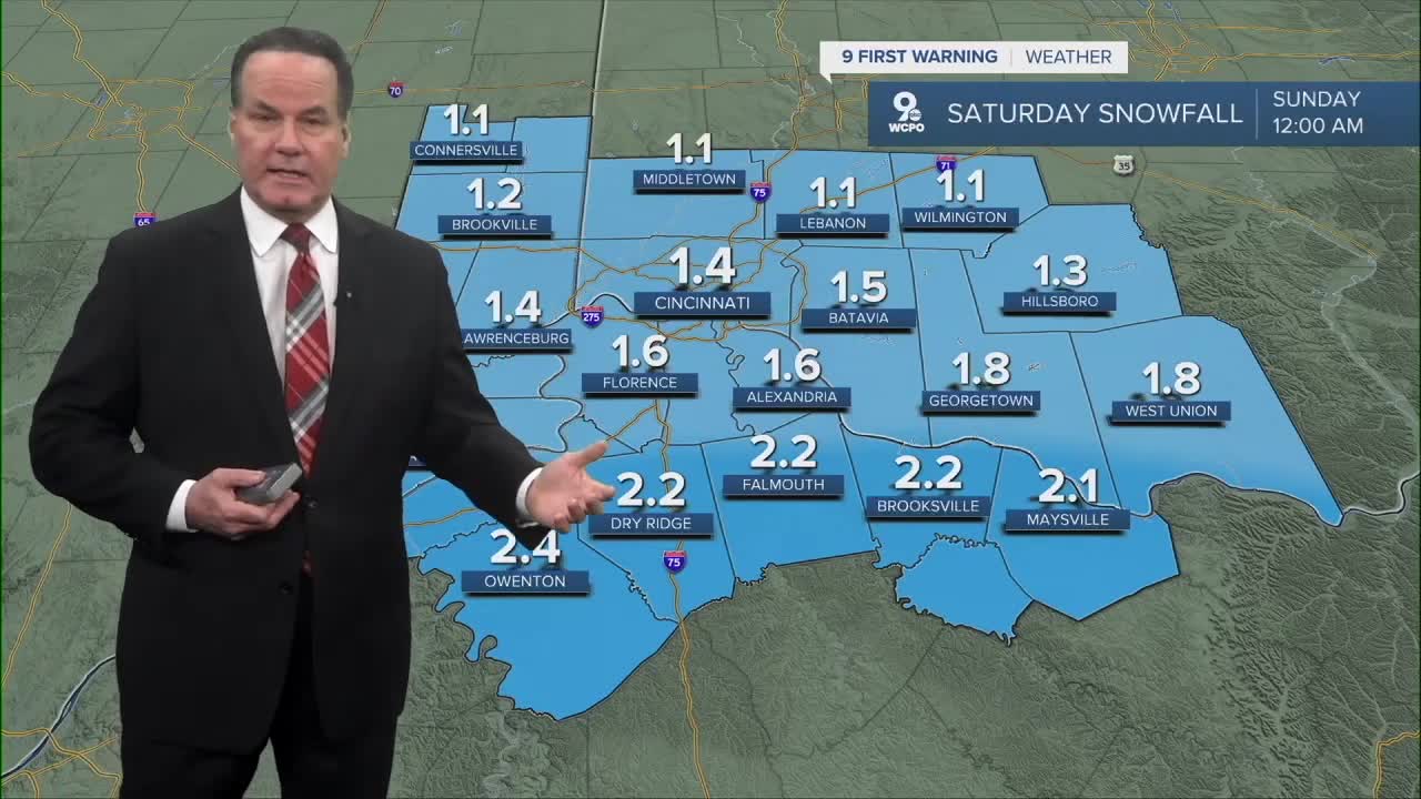
SATURDAY AFTERNOON: Snow develops, and it will be slow to accumulate. Temperatures will still be very cold as highs only reach the low to mid-teens.
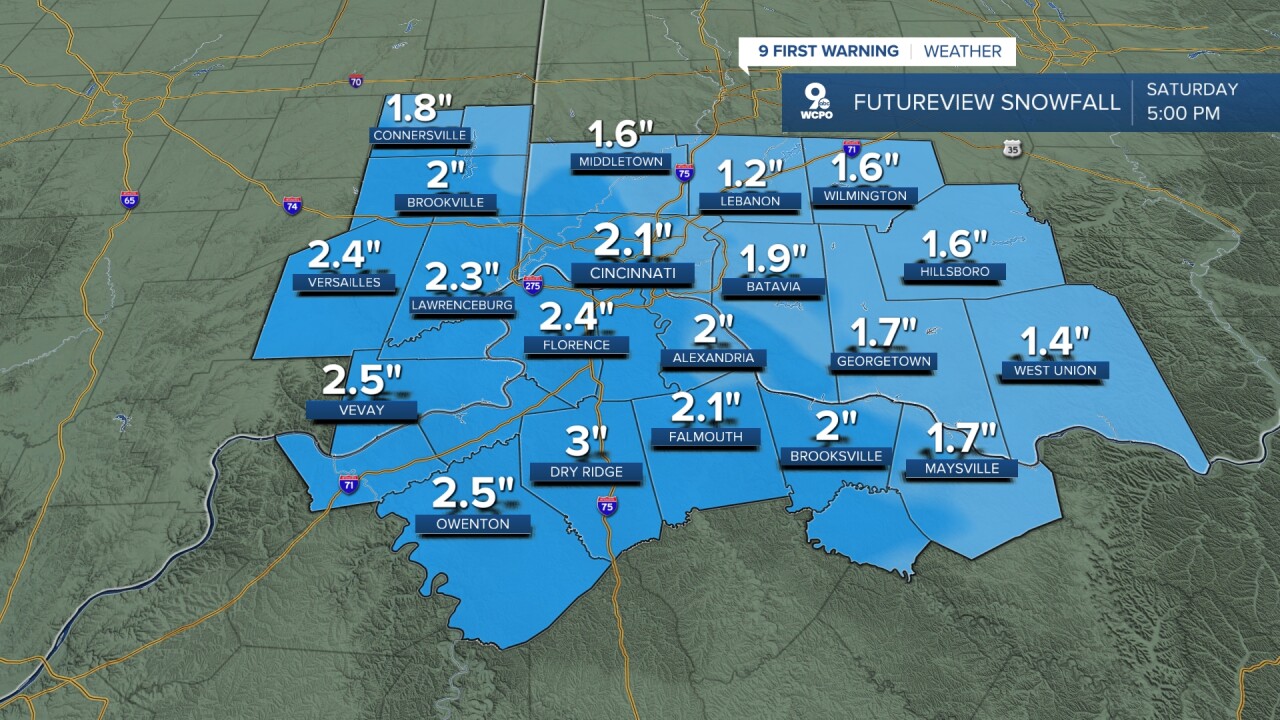
SATURDAY NIGHT: As snow continues, we will see a couple of inches of snow 6-7 pm, and totals will keep growing toward midnight. Moderate snowfall will come down all night.
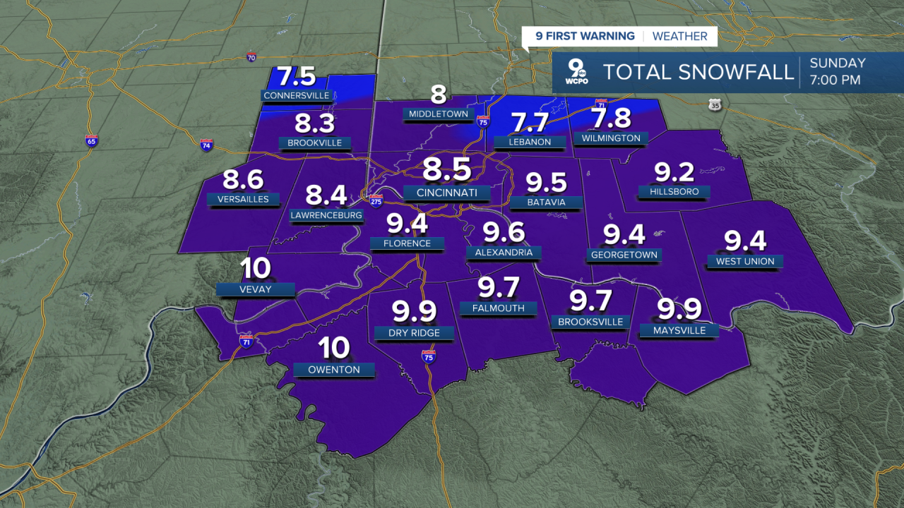
SUNDAY MORNING: Snow continues! By the time the sun rises, we'll likely see 4"-8" of snow on the ground.

SUNDAY: Sunday's forecast is where things get a bit more complicated, and the roads will be difficult or impassable at times.

While we are generally looking at snow throughout the storm, to the south and southeast, a wintry mix could make an appearance. Our models are showing a wedge of warm air just off the surface, and this could produce sleet or even freezing rain.
If the wintry mix sets up, it will change the snow totals. Conversely, if the snow continues, the snowfall total could top 10". Of course, roads will not be in good shape either way.
While the snow will be ending Sunday night, the impact on travel conditions will linger into Monday morning.
OVERNIGHT
Overcast
Much colder, feels like -12
Low: 4
SATURDAY
Snow Develops
Accumulation begins in the evening
High: 15
SATURDAY NIGHT
Snow
Roads becoming difficult
Low: 12
SUNDAY
Heavy snow
Periods of sleet a chance for freezing rain
High: 20
9 First Warning Weather 24/7 Livestream
==========
- Interactive Radar: Track weather to your doorstep
- Sign up for severe weather email alerts
- Check latest school closings and delays
- WCPO traffic updates
- Metro bus detours and updates (or call the hotline at 513-632-7538)
- Latest power outages from Duke Energy
- Flight cancellations and delays from CVG, other U.S. airports
