


Cincinnati set a new record high temperature for March 22 by warming up to 86 this afternoon. That heat could help fuel tonight's storms as a cold front arrives, so a Weather Alert Day has been issued.

A Severe Storm Watch has been issued for SE Indiana, SW Ohio, and far northern Kentucky until midnight. Secure any items outdoors and review your safety plan with your family.

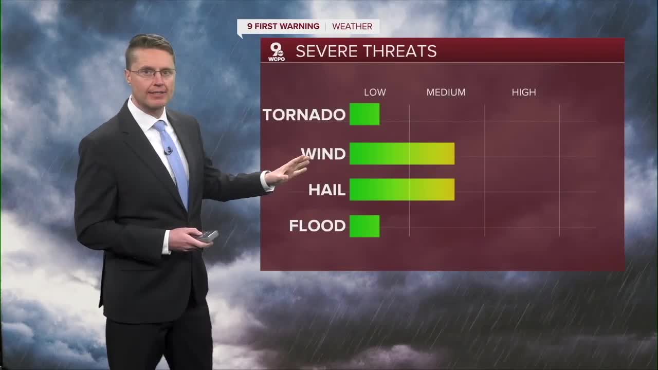
As the cold front approaches, as early as 9pm, we could see a couple isolated storms pop up in the Tri-State. Most of us will have to wait for the line of storms just ahead of the cold front later tonight. If these storms reach severe levels, damaging wind will be the main concern along with a few pockets of hail.

These storms likely push into SE Indiana around 10pm, then make it to Greater Cincinnati between 11 and midnight. By 1am, the strongest storms will be in northern Kentucky and south central Ohio. Everyone should be dry by 3am.

It will be breezy overnight as cooler weather blows in behind the cold front and storms. Monday starts in the upper 30s with a lot of clouds. The afternoon brings more sunshine. Highs will be a touch below average, in the low 50s.

Tuesday brings some good sunshine as we warm back into the mid 50s, which is average for late March.
The small warm-up continues Wednesday into the mid 60s. We could then see some light rain overnight and into Thursday morning.
The Opening Day parade looks dry right now. It will be mostly cloudy, a bit breezy, and warmer in the afternoon with low 70s. It's still not certain exactly when our next cold front arrives, but it will likely bring rain in the evening or night. We'll keep you updated on our chances of getting in 9 dry innings, but right now, it looks like a lot of dry baseball.
Some of the rain could continue into early Friday. It will also be chilly with upper 40s in the afternoon.
We warm up into the 50s for the weekend. Saturday brings some nice sunshine, but there is a small chance for rain Sunday.
Then, it's back to the 60s early next week.
OVERNIGHT
Mostly cloudy
Storms
Breezy
Low: 39
MONDAY
Clearing skies
Cooler
High: 51
MONDAY NIGHT
Partly cloudy
Cold
Low: 32
TUESDAY
Mostly sunny
Average
High: 56
9 First Warning Weather 24/7 Livestream
==========
- Interactive Radar: Track weather to your doorstep
- Sign up for severe weather email alerts
- Check latest school closings and delays
- WCPO traffic updates
- Metro bus detours and updates (or call the hotline at 513-632-7538)
- Latest power outages from Duke Energy
- Flight cancellations and delays from CVG, other U.S. airports
