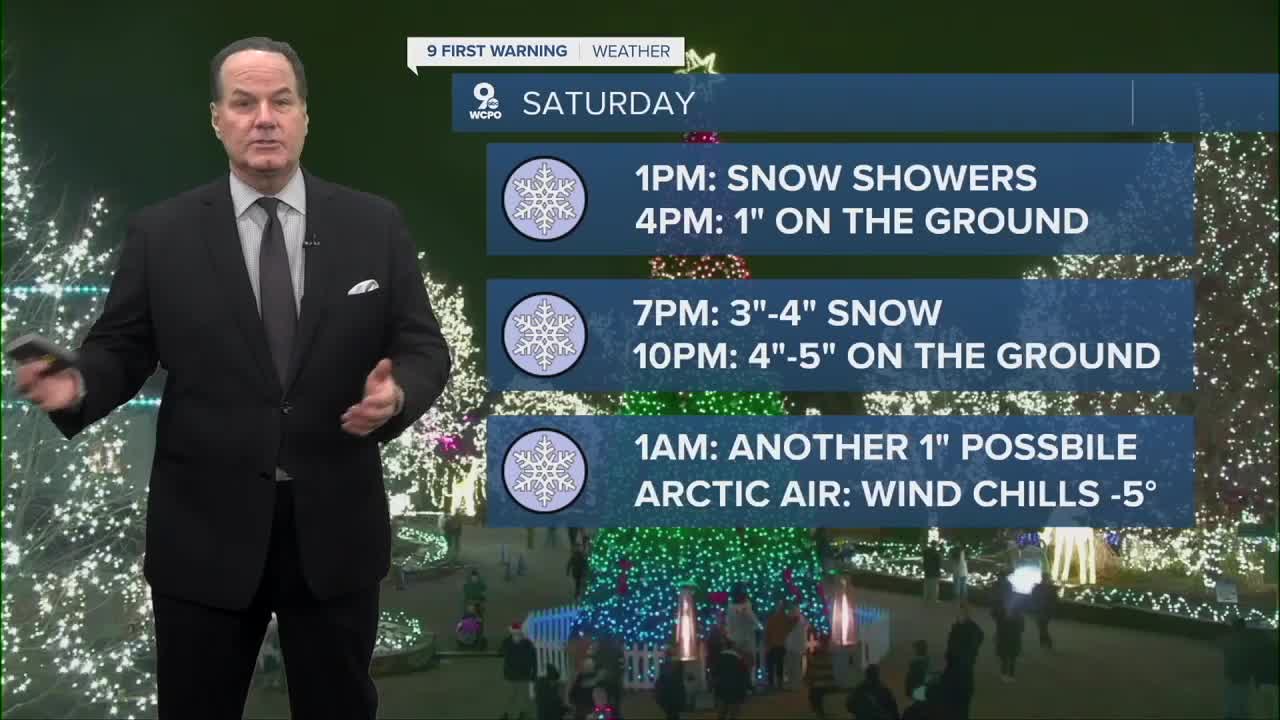


Cloudy skies settle over Cincinnati overnight, keeping temperatures from dropping too quickly but still allowing a chill to develop. Morning lows will fall into the mid-20s, so it will feel cold but calm. By later Saturday morning, expect more clouds to thicken overhead as the atmosphere prepares for round two of snow. The air will stay dry through the first half of the day, but around 1 p.m., snow is expected will start around the Tri-State.

Most areas can expect 3 to 5 inches of snow, and the reason for this higher total has a lot to do with something called the SLR, or the Snow-to-Liquid Ratio. This simply compares how much snow you get from an inch of liquid water. A typical winter storm might have a ratio of about 10:1, meaning one inch of water produces about 10 inches of snow. But this storm will have a much higher SLR, close to 20:1. That happens when the air is very cold, and the snowflakes form as light, fluffy crystals. They take up more space, so even a small amount of moisture produces a larger depth of snow. In other words, the snow will pile up quickly even though the system doesn’t have a lot of liquid content.

Once the snow ends Saturday night, our attention shifts to a powerful arctic blast pushing into the Ohio Valley. Sunday morning will bring “feels-like” temperatures below zero, thanks to extremely cold air. Even during the Bengals game, air temperatures will climb only into the teens, with wind chills remaining quite low.
If you’re heading to the stadium, be prepared for dangerous cold. Limit time with skin exposed, wear multiple layers, cover your hands, face, and ears, and take breaks indoors when possible. Frostbite can begin in minutes under these conditions, so caution is essential for anyone spending time outside.
OVERNIGHT
Overcast
Cold
Low: 26
SATURDAY
Mostly cloudy morning
Afternoon Snow
High: 29
SATURDAY NIGHT
Snow ends overnight
Snow covered roads expected
Low: 4
SUNDAY
Mostly sunny
Bitterly cold
High: 12
9 First Warning Weather 24/7 Livestream
==========
- Interactive Radar: Track weather to your doorstep
- Sign up for severe weather email alerts
- Check latest school closings and delays
- WCPO traffic updates
- Metro bus detours and updates (or call the hotline at 513-632-7538)
- Latest power outages from Duke Energy
- Flight cancellations and delays from CVG, other U.S. airports
