


Monday is a 9 First Warning Weather Alert Day due to the potential at strong and severe storms across the Tri-State.
Our confidence that these storms will pose a threat at becoming severe as they progress into the Ohio River Valley has increased, which is why we have declared Monday a Weather Alert Day. A warm front will pass through the Tri-State from the southwest during the morning hours Monday. This will usher in a hot and moist airmass which will prime us for the chance at strong and severe storms during the afternoon and evening hours Monday. It currently looks as though storms will cluster into what we call a squall-line, possibly even a Mesoscale Convective System (MCS), which is a larger scale storm cluster.
The Storm Prediction Center includes the entire Tri-State in their “Slight Risk” (Level 2 of 5) for severe weather Monday afternoon and evening.

STORM IMPACTS/HAZARDS:
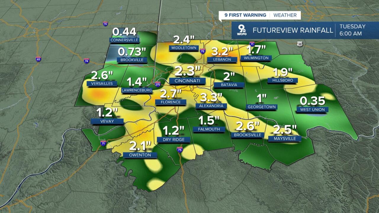
The primary concern with storms will be damaging straight-line wind gusts of 60 to 65 mph, but with the amount of energy and moisture we will have in these storms, I would not be surprised if we see some gusts reach near 70 mph. With winds that strong, power outages will be a concern along with downed trees. In addition to the strong winds in these storms, heavy rainfall will be likely as well. These storms could potentially start to “train” over our area, which means our threat for flooding would drastically increase, especially in low-lying and poor drainage areas are possible. MCS's tend to produce very heavy rainfall in areas that they pass through.
While I can’t rule out that we will see some hail, that isn’t as much of a concern. Tornadoes are not off the table but my concern for that remains low at this time.
TIMELINE:
The window for storms could open up as as early as 2 p.m. to 3 p.m. for areas of southeast Indiana as well as Butler and Warren counties. However, the main severe threat looks more confined to move in between 5 p.m. and 11 p.m. at this point. Storms will move in from the north northwest and have more of a southeasterly movement to them. This may lead to prolonged periods of heavy rain. Showers should come to an end by 2 a.m. in Northern Kentucky as a cold front passes through, which will end the event.


WHAT WE NEED TO WATCH:
When forecasting storms we look for many ingredients, but there are four main factors that really determine severe weather. I use the acronym of S.L.I.M. This covers Shear, Lift, Instability, & Moisture. Shear is a measure of the spin in the atmosphere, which you need for storms to turn and strengthen. Lift is what helps these storms develop with an upward motion to push the storms higher in the atmosphere. Instability measures the energy in the atmosphere for storms to feed off of. The higher those level get, the stronger storms are able to become. Lastly, Moisture. You can’t have storms without moisture, but the higher the levels, the better the threat for strong storms & tornadoes.

One of the only questions I would say we have is the "shear" aspect of S.L.I.M. but even those values look pretty decent. Parameters look good enough to support strong storms, but whether or not they line up with these storms as they come through is the question. However, there should be enough turn in the atmosphere to create some strong winds within these storms.

Lift will be available as a cold front to our north will help spark storms upstream into central Indiana earlier in the afternoon. However, if these don't develop upstream then we may have a little bit more difficulty getting storms to fire up here, but for now I don't anticipate that happening.. Instability is the next up on the list and that looks to be one of our strongest parameters. Numbers will be well above our threshold for severe storms with energy levels of 2,500+ J/KG across the entire Tri State.
Finally, moisture. That will not be an issue whatsoever, as our dew points should be sky high by midday Monday. Anything above 67° should be good enough for storms and we will be well above that mark, with dewpoints ranging from 70° to 75°.

As always, make sure to stay weather alert Monday. We will have coverage for you on-air when needed, but you can also stream coverage this afternoon on your WCPO Phone App as well as on our streaming app on your Roku, Amazon Fire, and Apple TV devices. Keep checking in for the latest updates as we get closer and closer.
