


CINCINNATI — We are in the midst of an active week here across the Tri-State and it picks up as we move through the middle of the week. Both Tuesday and Wednesday are 9 First Warning Weather Alert Days due to the threat of severe weather including tornadoes.
There will be multiple rounds and times to watch for with these severe weather events. So let's break down the elements.
TUESDAY
The Storm Prediction Center (SPC) has all of the Tri-State within a Slight Risk (level 2 out of 5) for severe weather on Tuesday, and they just upgraded areas to the north to an Enhanced Risk.
9 FIRST WARNING: The Storm Prediction Center has placed parts of the Tri-State in an Enhanced Risk for severe weather Tuesday. Tornadoes and large hail are the primary threats with this risk. Make sure to stay weather aware this week! #wcpo @wcpo #cincywx #ohwx pic.twitter.com/0N9YdQIHfp
— Brandon Spinner WCPO (@wxSpinner89) May 6, 2024
This risk includes all severe weather elements, however tornadoes and large hail look to be the primary concerns on Tuesday. The areas inside the Enhanced Risk are within the region with a higher probability of strong tornadoes. In addition to that, the entire Tri-State, including Cincinnati, will be in an increase risk for very large hail. The risk includes a great probability that we could see hail of 2 inches in diameter or larger. For perspective, an average hen egg is around 2 inches. Damaging wind gusts of 60 mph will be possible as well, but that looks to be the lesser of the three weather impacts on Tuesday.

TIMING:
Tuesday's event will bring a few rounds of severe weather and the first one will have a major role on whether we see an increased threat later in the day. The first round of storms is likely to push in for the midday with impact between 11 a.m. and 3 p.m. This wave won't pack the punch that the later evening provides, but it will bring a threat for damaging winds, hail, and a few spin-up tornadoes. This comes in the form of a squall line, which will move west to east. The issue here, is whether it zaps the energy for later into the evening. This line will also add some humidity and moisture to the atmosphere, which could play a role later on in the evening.

The evening event is the one that brings the most concern on Tuesday. This is when the threat for larger hail and stronger tornadoes will be present. As storms form, they will become supercells, which pose the greater risk for dangerous weather. This window for storms opens up as early as 6 p.m. and will increase until around 9 p.m. However, the threat won't end until closer to midnight into Wednesday morning.

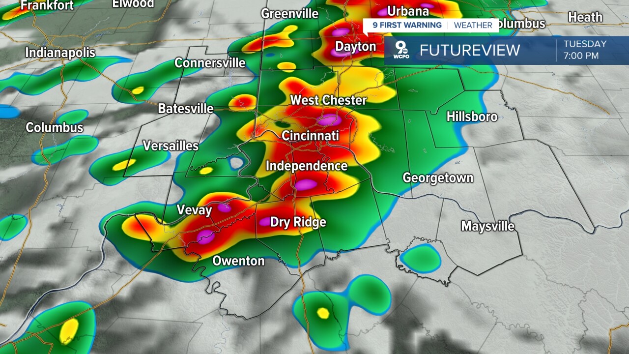
This round of storms could also bring some heavy rainfall which may lead to localized flooding. Street flooding and flask flooding will be possible as stronger storms develop. Rainfall totals within some of the stronger storms could be between 1 to 2 inches.
WEDNESDAY
Wednesday will be the day with the biggest severe threat of two here in the Tri-State. However, most of this will occur after sundown Wednesday evening into the overnight early Thursday morning.

The SPC already has placed the entire Tri-State in an "Enhanced Risk" for severe weather Wednesday, which is threat level 3 out of 5. This threat includes all forms of severe weather, including tornadoes, very large hail, and damaging winds. Their wording even says that "some of the tornadoes may be strong."

TIMING:
Wednesday's storms will be late in the afternoon and overnight into Thursday. The timing for this event is what makes this alarming. Most of the severe weather threat will occur after nightfall while many people are asleep. This is why it is important to always have multiple ways to get your severe weather warnings. Make sure that you charge all of your devices over the next two days. The latest computer model trends have storms as early as 3 p.m., but the bulk of the storms moving into the Tri-State after 7 p.m. Wednesday evening and pushing through midnight into the early morning hours of Thursday.


There will be some tweaks and changes to this forecast as we get closer to the event itself, so make sure to bookmark this page to keep checking for the latest updates as we get closer.
