


CINCINNATI — Monday’s cold front brought a blast of colder air to the Tri-State and we have even colder temperatures on the way overnight. That cold brings the potential for some patchy frost across the Tri-State overnight Tuesday into Wednesday morning, but will this be the last one of the season?
The scapegoat answer would be “possibly, but you never know!” but I am going to go out on a limb and say that we aren’t done just yet.
But why do I say that? First, let’s discuss what we need to see for frost to occur. There are three major “ingredients” that we look for when forecasting frost.
- Clear skies – Clear skies allows for radiational cooling to occur. This is basically just a fancy way of saying the daytime heat that is built up is allowed to escape from the earth’s surface rather than being trapped to the ground by cloud cover. This allows for temperatures to cool quickly and allows for even colder temperatures.
 WCPO
WCPOGraphical explanation of radiation cooling - Light surface winds – While you can’t see it, the air we breathe in is fluid. That means it has flow. When winds are stronger, that creates a greater flow which helps to mix the atmosphere up and create better temperature uniformity. Similar to how you would stir cream into your coffee. However, lighter winds allow for the coolest air to settle to the bottom of the of the surface, creating a thin layer of super-cooled temperatures near the ground. An example would be like pouring sugar into water and watching in settle to the bottom.
 WCPO
WCPOA look at why the ground is colder than the air - Cooler temperatures – Frost is a layer of ice and for ice you need temperatures that are 32°F or colder. The closer that air temperature is to 32°F, the better the chance to see frost.
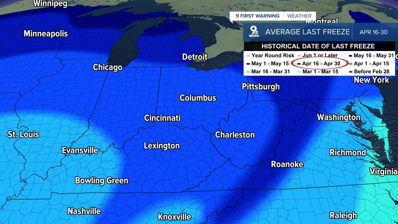
Now that we have the ingredients established, lets get into the statistics/climatology. Our 30-year average for our last freezing temperature in Cincinnati is April 23, which we are now past. That means we are past our average last freeze day. However, you can still get frost without a thermometer reading of 32°F.
Most thermometers take their observations around 5 feet off the ground, but as established above, we could still see freezing temperatures at the surface even when temperatures read above 32°F. Cold air is more dense than warm air, so that allows it to sink closer to the ground, which means the surface/ground is usually a few degrees colder. Generally speaking, the crossroads temperature for frost forecasting is around 36°.
The Cincinnati 30-year average for our last spring date with a temperature of 36°F or colder is actually May 1. However, in the last 10 years we have see that average jump to May 3, the latest of which was May 18, back in 2014. In fact, four of the last nine years we have seen our final 36°F temperature occur after May 10.
But what about this year? Long term model trends show that we will have some colder than normal air over the Tri-State for the first few weeks of May. Whether all the other ingredients are in place only time will tell.
