


A Weather Alert Day will be in effect on Wednesday.

Overnight and into Wednesday morning, a few showers and storms will make it into the region if they can hold together long enough. They could be strong enough to still have some strong wind and hail. That's why the Storm Prediction Center (SPC) has our area in a "marginal risk" for severe storms early Wednesday. It will also be warm in the morning with mid-60s.
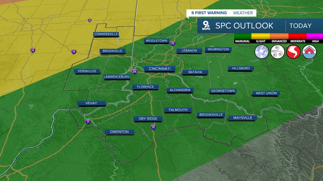
There's a better chance for storms on Wednesday afternoon as our next cold front arrives. If the morning rain ends early enough, the atmosphere could recharge enough early in the afternoon to give us a better chance for a few severe storms too. These likely enter the western part of the Tri-State around 3 pm, then move into Greater Cincinnati closer to 4. The strongest storms will then move into our eastern counties around 5 and 6.

Just like the morning storms, these could bring areas of large hail and strong winds, but a couple of tornadoes will also be possible. If anyone gets hit by a couple of storms, some brief flash flooding could happen until the drainage system catches up. The SPC has our area in a "slight" risk of severe storms.

Before the storms arrive, we should still have enough time to warm into the mid-70s in Cincinnati. Temperatures will fall behind the cold front sooner in southeast Indiana.
Much cooler air settles in behind this system, taking highs back to seasonal levels on Thursday. We'll start Thursday morning in the mid 30s and only warm into the upper 40s that afternoon with a partly cloudy sky.
Late Thursday night and into Friday morning, we could see a couple of pockets of light rain, but many of us stay dry.
Friday brings a nice warm-up back to 60 with a mix of sun and clouds.
Saturday will be partly cloudy with upper 50s, then we warm into the mid 60s Sunday with more clouds. A cold front arrives late Sunday with another round of rain. As strong wind blows in colder weather, we could get cold enough quickly enough to see the last bit of the rain change into some light snow by Monday morning.
A taste of winter returns Monday and Tuesday afternoons with highs only in the mid 30s.
OVERNIGHT
Mostly Cloudy
Storms Develop by daybreak
Low: 65
WEDNESDAY
Showers and storms
Severe storms possible
High: 74
WEDNESDAY NIGHT
Clouds move out
Temperatures fall quickly
Low: 36
9 First Warning Weather 24/7 Livestream
==========
- Interactive Radar: Track weather to your doorstep
- Sign up for severe weather email alerts
- Check latest school closings and delays
- WCPO traffic updates
- Metro bus detours and updates (or call the hotline at 513-632-7538)
- Latest power outages from Duke Energy
- Flight cancellations and delays from CVG, other U.S. airports
