


Showers and storms are moving into the Tri-State from the northwest. These will continue overnight through the early morning hours. It won't be a full washout, but expect a wet morning. Some downpours are expected at times.
Scattered storms will be off and on during the morning on Sunday. Some storms in the morning may be strong. On top of that, humidity will continue to climb through the day on Sunday, as will the warmth. Temperatures Sunday will be in the mid-80s and paired with humidity, it will feel slightly warmer. The Storm Prediction Center (SPC) has the entire Tennessee Valley in a Marginal Risk for severe storms Sunday. More isolated storms will be possible in the afternoon and evening.

Damaging winds will be the main concern with these storms, but large hail cannot be ruled out. The tornado threat is low, but non-zero. However, I don’t expect to see a tornado threat at this point. The timing for these storms will be
Strong storms will also be possible on Monday, as we are also included in a Marginal Risk from SPC. The main threats look to be winds again. Highs will be in the low 90s but with humidity it will more likely feel like 95-100 degrees much of the day.

As we look to next week, we are in for our first heat wave of 2022. And boy is it going to be hot. It looks as though that we will likely see high temperatures above 90-degrees at least four days in a row, from Monday through Thursday. Friday will be close too.
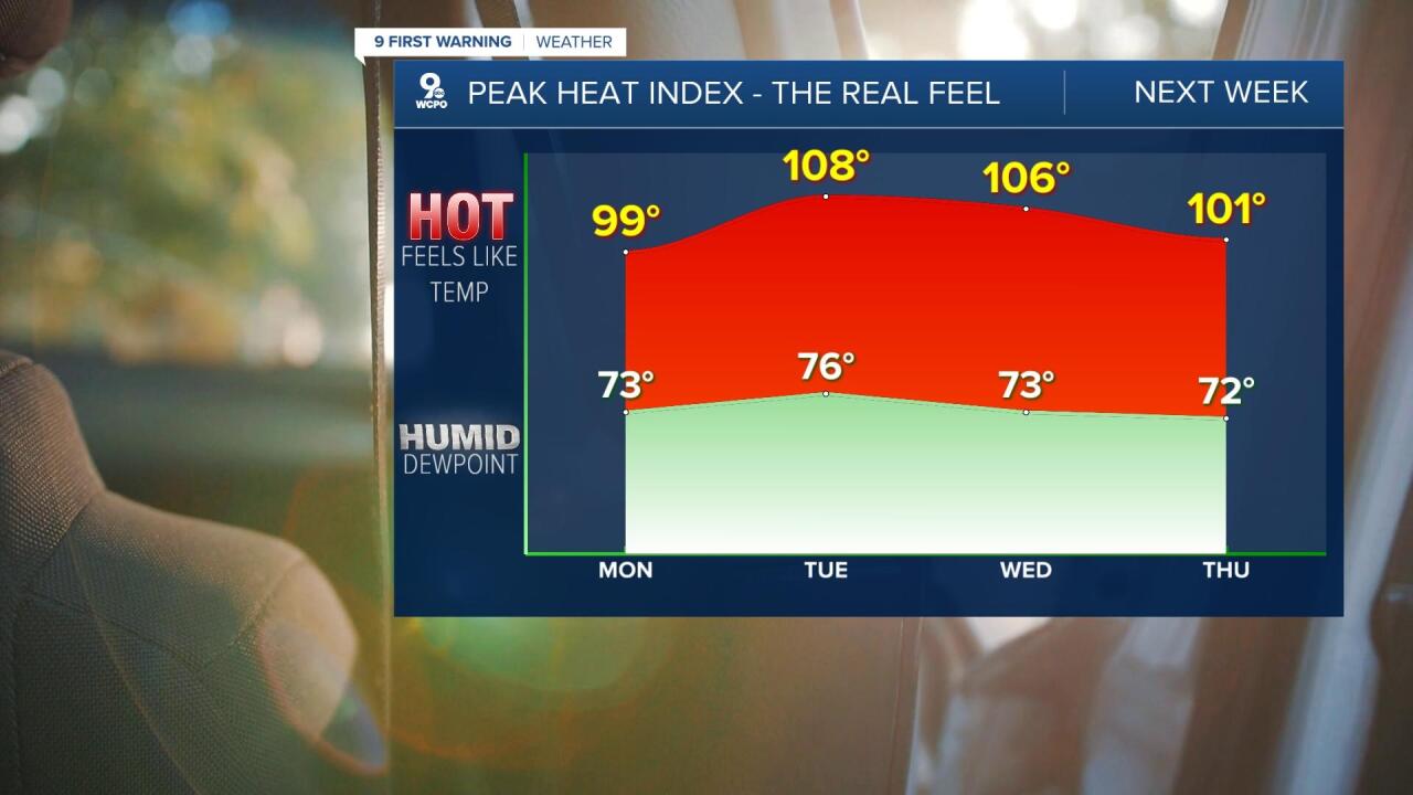
Unfortunately, the humidity will be sky high as well, which will make it feel much warmer than the actual temperature. The heat index on Tuesday and Wednesday could be near 105°, if not higher. That is dangerous heat. Make sure you start hydrating now! It doesn’t look like we will get a break until next weekend, which will still be warm in the mid to upper 80s.
THIS EVENING
More clouds
Scattered showers
High: 79
TONIGHT
Mostly cloudy
A few showers
Low: 66
SUNDAY
More warmth & humidity
A few storms possible
High: 84
SUNDAY NIGHT
Scattered storms
Staying warm
Low: 68
MONDAY
Hot & humid
A few storms possible
High: 91
9 First Warning Weather 24/7 Livestream
==========
- Interactive Radar: Track weather to your doorstep
- Sign up for severe weather email alerts
- Check latest school closings and delays
- WCPO traffic updates
- Metro bus detours and updates (or call the hotline at 513-632-7538)
- Latest power outages from Duke Energy
- Flight cancellations and delays from CVG, other U.S. airports
