
MOUNT ORAB, Ohio -- A tornado hit Brown County Monday night, according to the National Weather Service.
The EF0 tornado touched down north of Mount Orab and was on the ground for about 1.8 miles, according to the NWS. Officials estimated the tornado had a maximum wind speed of 80 mph and a maximum path width of 75 yards.
The tornado touched down on the west side of U.S. Highway 68 near Donley Road, then crossed the highway and caused substantial tree damage to a grove several hundred yards east, according to the NWS. The tornado then continued northeast to Hillcrest Road, where it uprooted more trees, caused damage to the roof of a home and blew over a chimney. It continued damaging trees and lifted near Crawford-Day Road.
A tornado warning was issued at 10:04 p.m. Monday. Damage was found north of Mt. Orab by our crews. Photographer Adam Schrand found a power pole down on a truck and a roof ripped off a home. He couldn't see the roof nearby, but he said it was very dark in the area surrounding the damaged home.
A few images from our radar show what happened and why there are signs of a tornado. The first shows the strong storm as it entered Brown County.
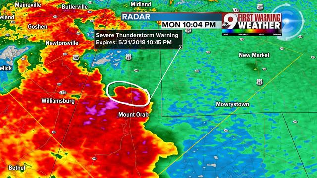
Reflectivity of strong storm
The second is the storm relative velocity and I've circled the area of broad rotation north of Mt. Orab. The red represents wind moving away from the radar and green is toward the radar. When they are close together like the area circled, that is often enough to prompt a tornado warning.

Area of rotation circled
The 3rd image shows a one-hour period of rotation. The red circles show the best rotation was indeed north of Mt. Orab and then it diminished before reaching New Market.

Pattern of rotation over 1 hour from 10-11 p.m. Monday
In all, it was about a nine-minute time frame of best rotation.
The NWS said they will provide more details later Tuesday.
