


We had another sunny afternoon on Tuesday but that didn't lead to a lot of warmth. Now the skies are clear and that colder air will continue overnight.
Mother Nature dealing us a little bit of whip lash. Temperatures today are 20-30 degrees cooler than where we were this time yesterday #WCPO @WCPO #OHwx #CincyWX pic.twitter.com/kSIM8nuU4y
— Brandon Spinner WCPO (@wxSpinner89) March 7, 2023
Overnight we fall into the upper 20s for much of the area as skies start off mostly clear. However, will end mostly cloudy as an influx of moisture comes in from the west. Winds will be from the northeast at 5 to 10 mph as well, which means we could see chills into the low 20s to start the morning.
Wednesday morning is going to be an interesting one. Clouds will be widerspread to start the morning with temperatures into the upper 20s. There may even be a few isolated showers to the southwest of the city between 7 to 9 a.m. As we open up the morning we will have a chances at some snow showers or sprinkles as a system to the west southwest rolls in. Right now, the bulk of the moisture should stay into southern Kentucky. The best time for this will be between 7 a.m. and 10 a.m. No accumulation is expected.
The rest of Wednesday will be dry and mostly cloudy with temperatures ranging from 45 to 48 degrees. Winds will still be from the northeast at 10 mph as a few more areas of sunshine pop up later in the afternoon. Thursday is another mostly cloudy and cool day with a high of 50.
The next best chance for rain arrives on Friday with our next area of low pressure. This is going to bring in showers after 10 to 11 p.m. on Thursday with the better rain on the way early on Friday. Depending on the track of the low pressure system, it's possible that a few of our very northern locations may see some wet snow mixing in with the rain. Temperatures will start in the 50s for the morning hours before dropping into the afternoon. There is a chance that some areas see a dusting of snow, but that confidence is low right now.

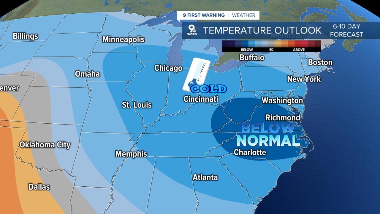
So what's going on? Where's the warmth? The days of 70 degree or higher temperatures will be gone for a few weeks. We have seen a shift in the jet stream that is now allowing more cold air to funnel into the portion of the country and those strong, southwest winds brings warmth have been shut down. The Climate Prediction Center has the Tri-State highlighted in the cooler than normal pattern for the week of St. Patrick's Day.
TUESDAY EVENING
Mostly clear
Staying cool
High: 49
TUESDAY NIGHT
Clouds roll in
Colder
Low: 29
WEDNESDAY
Mostly cloudy
Early flurries or showers
High: 47
WEDNESDAY NIGHT
Mostly cloudy
Chilly
Low: 29
9 First Warning Weather 24/7 Livestream
==========
- Interactive Radar: Track weather to your doorstep
- Sign up for severe weather email alerts
- Check latest school closings and delays
- WCPO traffic updates
- Metro bus detours and updates (or call the hotline at 513-632-7538)
- Latest power outages from Duke Energy
- Flight cancellations and delays from CVG, other U.S. airports
