


Heat and humidity are once again the top weather story today but there are changes ahead!
The Severe Thunderstorm Watch for Clinton, Highland, and Adams county has been CANCELED!
9 FIRST WARNING: A Severe Thunderstorm Watch has been issued for Clinton, Highland, and Adams county until 9 p.m.Strong storms this afternoon are possible & damaging winds are our primary concern along with heavy rain! Stay alert@wcpo #CincyWX #OHwx #NKYwx #INwx #WCPO pic.twitter.com/94Z70qP6Nl
— Brandon Spinner WCPO (@wxSpinner89) June 16, 2022
A cold front is finally making its way toward the Ohio Valley and will bring us relief from this heat... Tomorrow. Well ahead of this boundary, we are seeing some showers and storms pop up in central Ohio.
The cold front settles south overnight and along it, showers and thunderstorms are going to impact the Ohio Valley. Unfortunately, there is high uncertainty as to exactly where a larger cluster of storms will exactly end up early Friday morning.
It's very possible that this wave of storms could miss many of our northern and eastern locations. The more likely scenario is that storms could brush our very western and southern counties. Because of the energy and moisture in the atmosphere, I wouldn't be surprised to see decent downpours if not an isolated stronger storm.
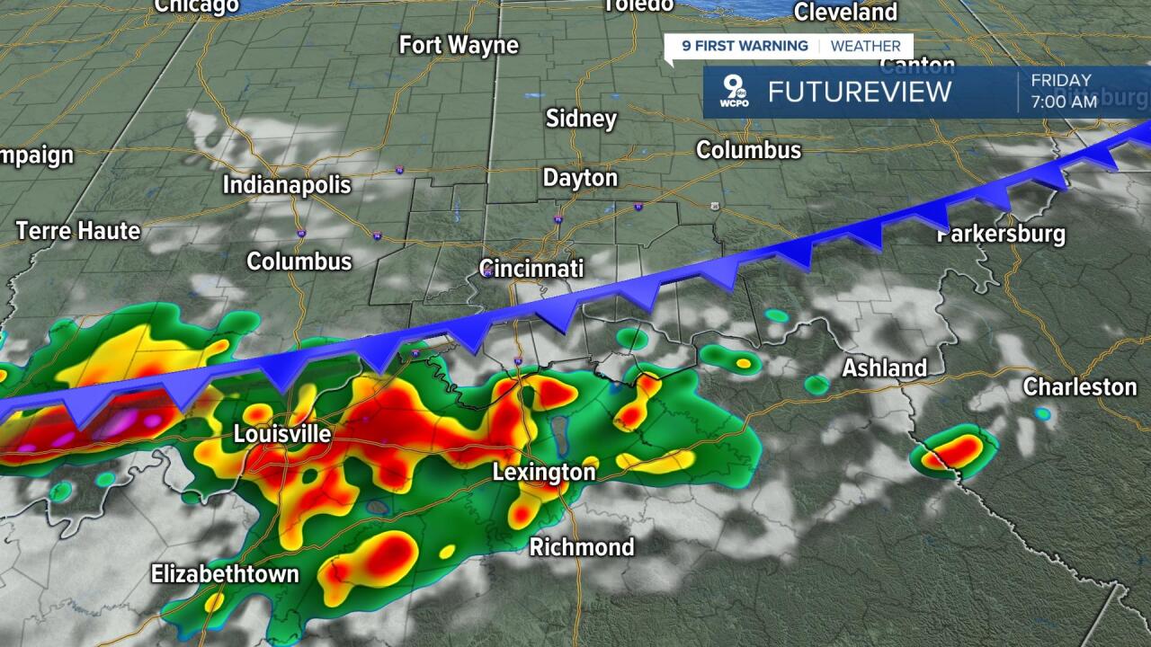
Rain is only a concern prior to 9 a.m. on Friday. After that, the story officially changes for a few days! Dew points will plummet during the day Friday, taking away that oppressive humidity. Clouds will linger early but we will turn mostly sunny quickly with a high of 88degrees. The Reds play at home Friday evening and it will be a great night for baseball.
Saturday and Sunday will feel significantly different. It will be cool and refreshing in the morning hours followed mild afternoon weather. Temperatures start around 60 on Saturday morning and the high only rises to 77 under a sunny sky. Sunday starts at 52 and warms to 80 with a mostly sunny sky. It's going to be a GREAT weekend to get outside.
Another heat wave is taking shape for next week and there are some indications that this could be worse than what we experienced this week. Highs will easily be back in the mid 90s if not warmer!
THURSDAY
Mostly sunny to partly cloudy
Isolated afternoon storms
High: 93
THURSDAY NIGHT
Storms possible
Partly cloudy, muggy
Low: 72
FRIDAY
Early morning storms to south
Turning mostly sunny, not as humid
High: 88
FRIDAY NIGHT
Cooling nicely
Lower humidity
Low: 60
SATURDAY
Picture perfect!
Sunny with lower humidity
High: 77
9 First Warning Weather 24/7 Livestream
==========
- Interactive Radar: Track weather to your doorstep
- Sign up for severe weather email alerts
- Check latest school closings and delays
- WCPO traffic updates
- Metro bus detours and updates (or call the hotline at 513-632-7538)
- Latest power outages from Duke Energy
- Flight cancellations and delays from CVG, other U.S. airports
