


We will see more cloud cover build as temperatures stay mild overnight into Monday. Lows will be into the low 60s, around 61° for Cincinnati. While a majority of the overnight will stay dry, we could see some rain move in by 5 a.m. to 6 a.m. as we move into the morning drive. Unfortunately, it looks like once the rain moves in it will be with us for a majority of the day. So, keep that in mind for the morning commute.


Scattered storms will be with us most of the morning on Monday as the rain will be with us into the early afternoon. Because of the clouds and rain, our temperatures should be much cooler, only climbing into the upper 60s and low 70s. This is just the start of what looks to be a very active week from start to finish.
9 FIRST WARNING: The entire Tri-State is in a "Slight Risk" (level 2 of 5) for severe weather on Tuesday. This includes downtown Cincinnati. All forms of severe weather are possible at this point @wcpo #wcpo #cincywx #ohwx #nkywx #inwx pic.twitter.com/U0qRXJQtsJ
— Brandon Spinner WCPO (@wxSpinner89) May 5, 2024
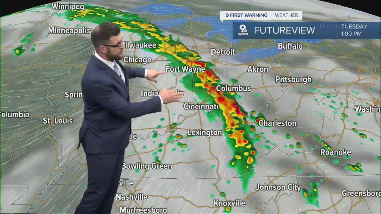
Tuesday will bring us another threat for rain and storms. These storms have potential to become strong and/or severe. The entire Tri-State is in a "Slight Risk" (level 2 of 5) for severe weather on Tuesday. All forms of severe weather are possible at this point. And we may have an encore for Wednesday as well.
Additionally, the Tri-State is also already included in a Slight Risk for severe weather on Wednesday. Still early, but both Tuesday and Wednesday are days you need to stay weather aware. #wcpo @wcpo #cincywx pic.twitter.com/g11tYvwY3s
— Brandon Spinner WCPO (@wxSpinner89) May 5, 2024
Tuesday and Wednesday will also both have a shot at the 80s for temperatures with high humidity.
TODAY
Warm & muggy
Isolated afternoon storms
High: 78
TONIGHT
Mostly cloudy
Chance storms
Low: 61
MONDAY
Showers and storms
Heavy at times
High: 69
MONDAY NIGHT
Isolated storms
Staying warm & muggy
Low: 61
9 First Warning Weather 24/7 Livestream
==========
- Interactive Radar: Track weather to your doorstep
- Sign up for severe weather email alerts
- Check latest school closings and delays
- WCPO traffic updates
- Metro bus detours and updates (or call the hotline at 513-632-7538)
- Latest power outages from Duke Energy
- Flight cancellations and delays from CVG, other U.S. airports
