


CINCINNATI -- A major mixed-use trail proposal in the Tri-State is about to get a new name, and with it an even wider scope.
Formerly called Cincinnati Connects, the CROWN -- that is, the Cincinnati Riding or Walking Network -- consists of a number of cycling advocates, trail builders and community leaders committed to creating what could become a more-than 100-mile trail network throughout the city. That would include both existing on- and off-road bike lanes and trails, as well as projects in progress.
It would also put roughly 242,000 Cincinnati residents within a mile of paved trail access, according to chair of local advocacy group Tri-State Trails, Frank Henson.
"This is a bold, new vision," Henson said.
The idea is to connect four major trail projects currently underway: the Mill Creek Greenway Trail, the Ohio River West Trail, the Oasis Trail and Wasson Way Trail, among other smaller trails throughout the county and along the riverfront, Henson said. The plan would also build six new connector trails in order to complete the network.
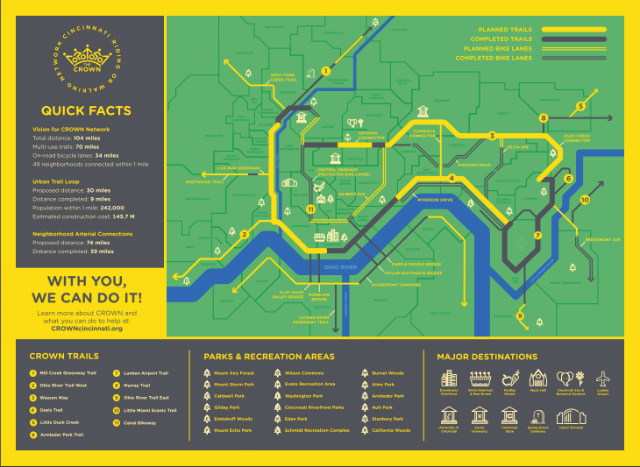
The proposed Cincinnati Riding and Walking Network, or CROWN. (Provided)
Tri-State Trails teamed up with Queen City Bike, Red Bike, and the Urban Basin Bicycle Club as the major organizations behind the plan, which they unveiled Wednesday during a meet-and-greet at the foot of the Roebling Bridge in Smale Park. That stretch of the riverfront is part of the Ohio River Trail, extending east into Sawyer Point.
"It's a collaboration with any and all of the groups and people who are interested in developing this active transportation network," Henson said.
While the trail system is in proximity of such a large portion of Cincinnati residents, even those living beyond the city limits see major value in it.
Joe Humpert of Fort Wright in Northern Kentucky commutes almost exclusively by bicycle and attended today's unveiling.
"I've always enjoyed it because it saves me from having to worry about gas and insurance and paying for parking and finding parking," he said.
But he said the region would benefit from more trails being connected.
"I spend a lot of time riding on the road right now," he said.
The CROWN would connect -- via the Purple People Bridge -- with the also in-progress Riverfront Commons project stretching across Northern Kentucky's riverfront, which also connects with the Licking River Greenway heading south into Kenton County.
Henson said CROWN expands upon what organizers did with Cincinnati Connects, in that it now incorporates elements of the city's bicycle transportation plan, a 15-year plan first established in 2010, but one that hasn't gotten as much traction as advocates initially hoped.
"It has taken the Cincinnati Connects plan with elements of the bicycle transportation plan," Henson said. "I believe it's going to create a vibrant active transportation network."
Those elements include things like the Central Parkway protected bike lane, other striped bike lanes, and shared-use traffic lanes that boast "sharrows" -- that is, painted arrows indicating frequent bike traffic sharing the road along the route.
The initial trail design came from 15 months of technical work and planning, looping representatives from the city administration, Queen City Bike, Great Parks of Hamilton County, the Cincinnati Park Board, the Cincinnati Health Department, OKI Regional Council of Governments and Interact for Health, among others.
CROWN spray painted its logo on various spots along the trails that will become part of the network. Here's one at Yeatman's Cove. (Pat LaFleur/WCPO)
Folding in the city's bike lanes added more connectivity to the plan, Henson said, especially to the region's more central neighborhoods.
"It became apparent that having a circular route around the city really didn't get people into the core of our community," he said. "It touches all the edges, but in order to get people beyond that, we looked and saw these various connectors."
Henson calls it a "braided network."
"Just like the word means, you have interconnected, weaving connectors that allow people to get more places," he said.
The only missing piece is how organizers plan to pay for the necessary connector trails, which-- including remaining work on the major trails -- would total around $45 million.
"We're not sure how it'll get paid for yet," Henson said.
Funding possibilities primarily include state and federal grants, including those like the federal Congestion Mitigation/Air Quality grant, from which two of the major trails have already received funding in recent years.
Pat LaFleur reports on transportation and mobility for WCPO. Connect with him on Twitter (@pat_laFleur) and on Facebook.
