

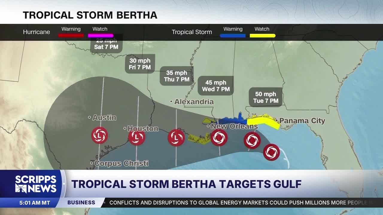


Tropical Storm Bertha is gaining strength in the north Gulf and is expected to hit portions of the Gulf Coast from Florida to Louisiana, and possibly as far west as Texas.
Heavy rain, coastal flooding and tropical storm-force winds are all possible through the week in its path.
The second named storm of the 2026 Atlantic hurricane season had winds of 60 mph as of Tuesday afternoon and additional strengthening is possible. Forecasters said the tropical storm had become better organized over the previous 24 hours.
A Tropical Storm Warning is in effect for areas of the Gulf Coast from the Alabama/Florida border to the Jefferson/Plaquemines Parish border in Louisiana.
A tropical storm watch has been issued for the coast of the Bay/Gulf County line in Florida westward to the Florida/Alabama border, west of the Jefferson/Plaquemines Parish border to Morgan City, Louisiana, and metropolitan New Orleans. In these locations, tropical storm conditions are possible within the next 24 to 48 hours. Additional watches could be issued farther west along the Louisiana and Texas coast in the next day or two.
IN CASE YOU MISSED IT | Tropical Storm Arthur, first of 2026 Atlantic hurricane season, makes landfall
Atlantic hurricane season has gotten off to a slow start compared to recent years as El Niño tightens its grip on parts of the basin.
The National Oceanic and Atmospheric Administration predicts a lower-than-average number of named systems in the Atlantic this season because of it.
Storm track, intensity
Bertha will most likely track along or make landfall on the northern Gulf Coast near southeast Louisiana and southern Mississippi by Wednesday.
This would prevent it from intensifying much because tropical systems weaken over land. It would also face an increasing amount of storm-killing wind shear, which is the change in speed or direction of winds in the upper levels of the atmosphere.
Those unfavorable factors could even cause the system to dissipate over Louisiana, but the latest forecast calls for it to reach the Upper Texas Coast as a tropical depression by late week.
Impacts expected on Gulf Coast
Regardless of the system’s fate, heavy rainfall, gusty winds and some coastal flooding will impact the northern Gulf Coast through at least midweek.
Here’s what to expect:
• Rainfall: Widespread totals of 2 to 4 inches, with up to 8 inches in the strongest thunderstorms, are possible from the western Florida Panhandle to southern portions of Alabama, Mississippi, Louisiana and possibly the Texas coast. This could trigger flash flooding, especially in urban areas like New Orleans.
• Wind: Tropical storm conditions — sustained winds of 39+ mph— are possible in the tropical storm watch area of the Florida Panhandle Monday night into Tuesday. Locations farther west in a tropical storm watch could see those conditions late Tuesday night into Wednesday. Higher gusts in thunderstorms could cause isolated power outages.
• Storm surge: Water levels could rise 2 to 4 feet above normal from the mouth of the Mississippi River in southeast Louisiana to the Alabama-Florida border. A storm surge watch is in effect for this area, which means life-threatening inundation of ocean water is possible in the next 48 hours.
The-CNN-Wire™ & © 2026 Cable News Network, Inc., a Warner Bros. Discovery Company. All rights reserved.
